What is the Best 3d Mapping Software for Utility Locators?
Choosing the right utility locating mapping software is crucial for businesses aiming to enhance the accuracy and efficiency of identifying underground utilities.
From ensuring excavation safety to facilitating real-time data integration, these tools represent the forefront of technology in utility locating.
Whether you're seeking to adopt your first mapping solution or upgrade your current system, our list aims to simplify your decision-making process, guiding you to the software that best fits your business needs.
Esri - ArcGis Utility Network

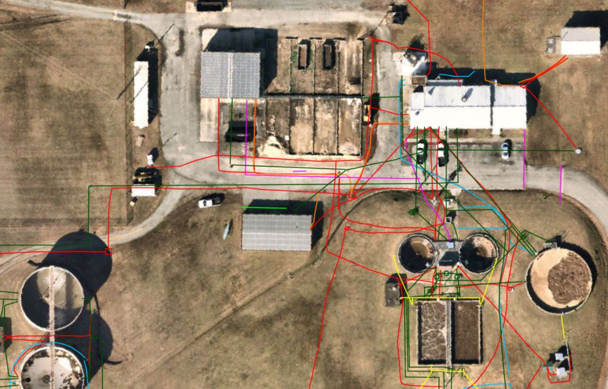
The ArcGIS Utility Network, provided by Esri, offers a comprehensive framework for organizing, managing, and optimizing the operations of utility networks.
It supports utility locating businesses by enabling detailed modeling of physical network systems, such as water, gas, electricity, and telecommunications.
This tool facilitates the visualization, analysis, and management of infrastructure, ensuring more efficient planning, maintenance, and decision-making processes for utilities.
https://www.esri.com/en-us/arcgis/products/arcgis-utility-network/overview
12d Model
The 12d Model software, as described on their website, specializes in civil engineering, water engineering, and land surveying in 3D, making it a powerful tool for utility locating businesses.
It enables the detailed design, analysis, and management of civil engineering projects and infrastructure, including roads, channels, and drainage systems.
This capability aids utility locators by providing precise topographical and subsurface data, which is crucial for planning, implementing, and managing utility detection and excavation projects efficiently.
AutoDesk
Autodesk offers a suite of software solutions that are highly relevant to utility locating businesses, including AutoCAD and Civil 3D.
These tools are designed for drafting, designing, and modeling infrastructure and utility systems in both 2D and 3D environments.
They enable professionals to create detailed simulations and analyses of utility networks, which aids in the planning, design, and management of utilities, enhancing accuracy and efficiency in locating and mapping underground utilities.
QGIS
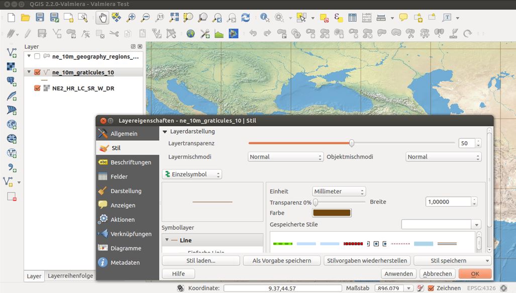
QGIS is a free and open-source Geographic Information System (GIS) that enables users to create, edit, visualize, analyze, and publish geospatial information on various platforms.
For utility locating businesses, QGIS provides a robust set of tools for mapping and analyzing utility networks, facilitating detailed spatial analysis and data management to support the identification and management of utility locations.
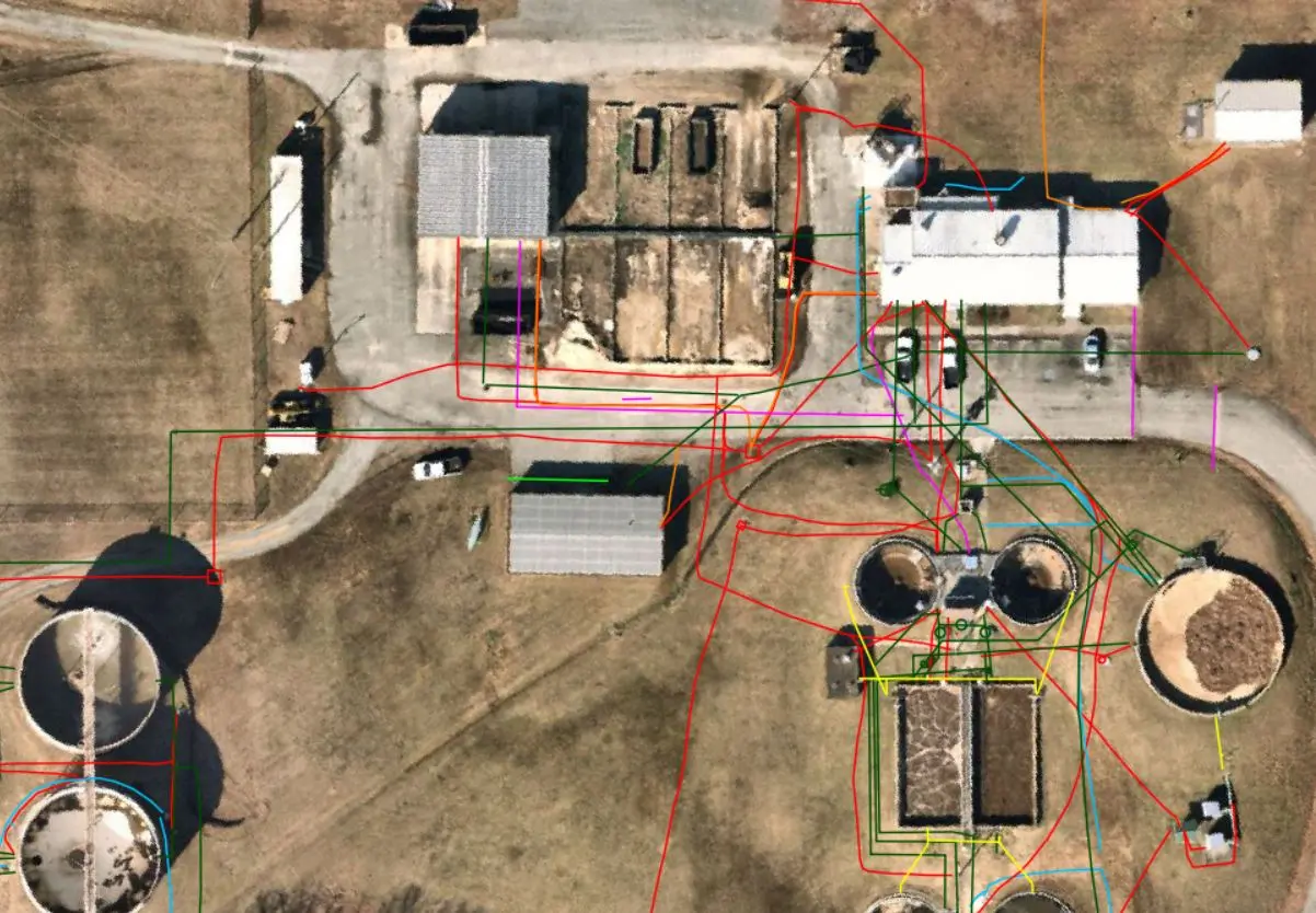
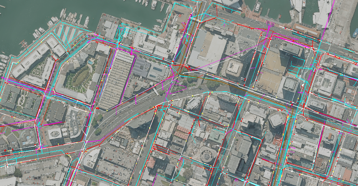
Centerline Mapping
Centerline Mapping offers utility locating and mapping solutions, specializing in damage prevention, GIS data management services, and providing mapping equipment and training.
They work with various sectors, including civil engineering, land surveying, and utility companies, to enhance productivity, jobsite safety, and profit margins.
Their services are aimed at reducing utility damages, updating and managing utility data through GIS applications, and supplying the necessary equipment and training for accurate utility mapping and data collection.
Geolantis
Geolantis offers cloud-based solutions that focus on asset management, underground utility mapping, and fieldwork automation.
Their platform likely aids utility locating businesses by providing tools for precise location tracking of underground infrastructure, data management, and collaboration in real-time, enhancing the efficiency and accuracy of utility detection and mapping efforts.
While I couldn't access their site directly, Geolantis is known for integrating GIS data with modern mapping technologies to support utility and infrastructure projects.
TerraFlow Utility Mapper
TerraFlow's Utility Mapper enhances utility locating businesses by enabling precise capture of locate information and its integration with business systems like GIS or Asset Management Systems.
It supports high accuracy GNSS positioning and utility locate sets, facilitating one-click capture of all locate and spatial information.
This technology streamlines the collection and management of utility data, improving accuracy and efficiency in utility mapping and damage prevention efforts.
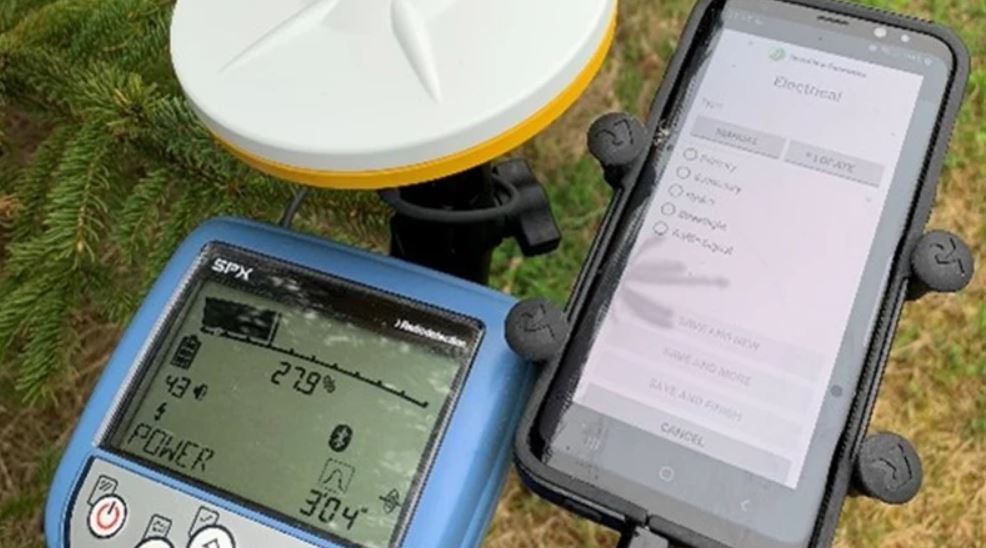
VMMap App

The VMMap App by Vivax-Metrotech is designed for utility locating businesses, enabling field technicians to record data via Bluetooth-enabled receivers, which is then accessible online through the VMMap Cloud.
It allows for accurate data collection, including depth readings and GPS coordinates, and supports exporting to various file formats compatible with GIS software.
This app enhances the precision of utility mapping with features like real-time map generation, image capture for surveys, and the ability to show multiple utilities on one map with color-coded pins.
Eos Locate For ArcGIS Software

The Eos Utility software is designed for configuring and monitoring Arrow GNSS receivers on Windows and Windows Mobile platforms, offered by Eos Positioning Systems.
It enables users to monitor GNSS receiver accuracy, track Atlas® satellites for differential corrections, and convert binary data to RINEX format for post-processing.
This tool is essential for utility locating businesses that require high-accuracy location data and GNSS tracking for mapping and managing utility assets efficiently.
https://eos-gnss.com/products/solutions/eos-locate-for-arcgis
Uinta Mapping Software

Uinta Mapping Software by Juniper Systems is designed for hassle-free data collection and professional mapping, supporting high-accuracy GPS positioning for utility asset mapping among other applications.
It's customizable, allowing for the creation of project templates that reflect specific job requirements, making it ideal for utility locating businesses for efficiently capturing, managing, and sharing locate information.
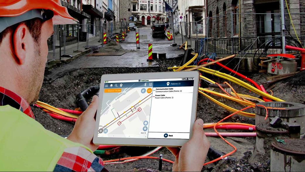
RD Map from Radiodetection

The RD Map from Radiodetection is a free Android app designed to support Bluetooth Precision locators, enabling technicians to map buried utilities directly from the field.
This app utilizes Google Maps to create detailed maps of underground utilities with standard color-coded markers and tracks.
It offers tools for correcting GPS inaccuracies and supports high-precision Bluetooth GPS/GNSS receivers for accurate positioning, making it a valuable tool for utility locating businesses in mapping and sharing utility locations efficiently.
https://www.radiodetection.com/en-au/products/data-solutions/rd-map
SW Maps by Aviyantech

SW Maps, developed by Aviyantech, is a free GIS and mobile mapping app designed for collecting, presenting, and sharing geographic information.
It supports a variety of data collection methods, including GNSS surveys, and offers features like overlaying multiple map layers, recording GPS tracks, and exporting data in various formats.
This makes it particularly useful for utility locating businesses in managing spatial data, conducting field surveys with high precision, and sharing collected data efficiently.
4M Analytics

4M Analytics specializes in underground utility mapping solutions, offering a comprehensive approach to utility risk mitigation and coordination from the pre-design stage.
Their platform aims to streamline the process of obtaining utility data without the need for physical site visits, leveraging advanced technologies to provide accurate mapping of subsurface infrastructure.
This service is particularly valuable for utility locating businesses seeking to avoid conflicts and streamline project planning and execution.
Norfield Software
Norfield offers a suite of software solutions, including Locator Logix, aimed at utility locating businesses to manage locate requests and utility locates with precision and efficiency.
Their platforms focus on improving workflow, communication, and data analysis for utilities, locators, and excavation teams, ensuring safety and reducing infrastructure risk through advanced GIS technology and ticket management.
KorTerra
KorTerra offers damage prevention and 811 ticket management solutions tailored for utility locating businesses.
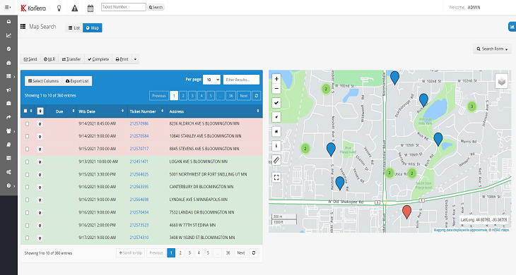
Their platform aims to improve the efficiency of locate operations, manage risk, and enhance productivity through features like field staff mobilization, automated ticket workflows, and GIS mapping data leverage.
This comprehensive approach helps utility locators and other stakeholders manage and complete tickets effectively, even in challenging environments.
Subsurface Solutions
Subsurface Solutions is dedicated to utility damage prevention, offering a wide range of products and services for locating and mapping utilities.
They provide cable and pipe locators, gas leak detection equipment, GPS utility mapping tools, and more, aiming to enhance safety and efficiency in identifying and managing underground utilities.
PointMan
PointMan is a cloud and mobile mapping software that captures, records, and displays the precise location of buried utilities and pipelines.
It offers unprecedented precision and associated metadata like type, depth, and cover depth, directly from standard mobile devices.
This technology is particularly beneficial for utility locating businesses by improving the accuracy of utility mapping, enhancing worker and public safety, and supporting efficient project management.
SmarterWX
SmarterWX offers a suite of applications designed to streamline workflows, reduce project costs, and save time for utility locating businesses.
Their products, including SmarterWX Automate, Locate, Collaborate, and Sentinel, focus on enhancing the efficiency of Before You Dig enquiry responses, tracking progress, facilitating collaboration on public works projects, and reinventing referral services with real-time dashboards and cloud access.
This platform is aimed at optimizing operational efficiency and decision-making in utility management.
Competers Inc
Competers Inc offers utility locate and management software solutions, including UtiLocate for locators, municipalities, and utility owners, and UExcavate for excavators and project managers. These tools are designed to improve operational efficiency, manage locates and excavation projects, and facilitate data management and communication between stakeholders, making them highly relevant for utility locating businesses.
Utilocate
Utilocate, created by Competers, is an underground utility locate software designed to streamline the management of locate tickets for 811 / One Call systems. It offers a full solution for coordinate locates, providing a centralized platform for all data and documents, automated responses, ESRI mapping integration, and tools for data collection, including photos and sketches. This software is aimed at improving efficiency and accuracy in utility locating operations.
Satellite Imagery:
Google Maps (Google My Maps/Google Earth)
Google Maps is an essential tool for utility locating businesses, providing detailed satellite imagery, street maps, and 360° street views. It assists in navigating to specific sites, visualizing the geography and infrastructure of areas, and planning the logistics of utility location operations. With its widespread accessibility and real-time traffic updates, Google Maps enhances efficiency in field operations by allowing for precise location tracking and route planning.
SIXMAPS
The website for SIX Maps provides access to spatial and mapping data for New South Wales, Australia.
Nearmaps
Nearmap offers high-resolution aerial imagery and geospatial data, which can significantly aid utility locators in planning, managing projects, and conducting detailed site analyses without the need for on-site visits. This platform provides current and historical aerial images, depth and height measurements, and AI-driven feature identification, making it a valuable tool for utility location and infrastructure planning tasks.
NationalMap
NationalMap is an Australian government initiative providing access to spatial data from Australian government agencies in an interactive map format.
Building Information Modelling (BIM) Software
BIM (Building Information Modeling) software is a type of software that is used for creating and managing 3D models of buildings and other structures.
These models can be used for a variety of purposes, including visualization, planning, and construction.
There are many different types of BIM software available, ranging from basic to advanced, and choosing the right one depends on the specific needs of the project.
Some popular BIM software includes: Autodesk Revit, AutoCAD, and SketchUp.
Briscad: Briscad software is a Computer-Aided Design (CAD) and Computer-Aided Manufacturing (CAM) software suite developed by Spartacus Systems. It is designed for precision engineering and manufacture, offering solutions for 2D and 3D drafting, sheet metal design, mold and die design, CAM and CNC simulation. Briscad is known for its advanced parametric modeling capabilities, allowing users to create complex 3D models with ease. It is also compatible with a wide range of file formats, making it a versatile tool for engineers and manufacturers.
Revit: Revit is a computer-aided design (CAD) software used by architects, engineers, and construction professionals for drafting, visualizing, and analyzing 3D models of buildings and infrastructure. Developed by Autodesk, Revit is known for its flexibility and versatility, allowing users to switch between different phases of a project including planning, design, and construction. It offers a wide range of tools and features that enable users to create accurate, detailed, and visually appealing models, as well as collaborate with other team members in real-time.
NavisWorks: Navigator (formerly known as NavisWorks) is a Construction Collaboration Platform by Autodesk. It allows project managers, designers, constructors, and field workers to access, mark up, and collaborate on models, drawings, and schedules in real-time. It also integrates with other project management and BIM tools like AutoCAD, Revit, and BIM 360. With Navigator, users can easily manage and coordinate tasks, track progress, and ensure projects stay on schedule and within budget. It is often used in industries such as architecture, construction, engineering, and infrastructure.