Introduction
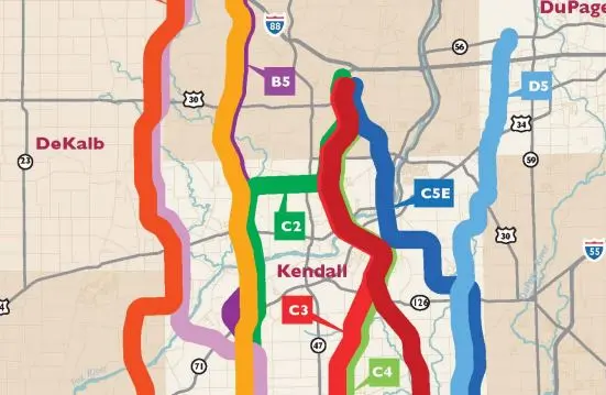
The Prairie Parkway SR-71 project, undertaken in Kendall County, IL, by a Subsurface Utility Engineering (SUE) company, showcases the critical role of precise utility mapping in infrastructure development.
The project focused on the identification and mapping of various gas, petroleum, and crude oil pipelines, with diameters ranging from 10 inches to 36 inches, within a designated area.
This case study details the methodologies adopted, the challenges encountered due to local soil conditions, and the significant impact of the SUE findings on the project's design phase.
Project Overview
The Illinois Department of Transportation (IDOT) District 3 required comprehensive utility mapping for the proposed Prairie Parkway SR-71, particularly to avoid conflicts with existing underground utilities in the area slated for an interchange.
The SUE company was tasked with performing Quality Level B (QL-B) and Quality Level A (QL-A) mapping to accurately locate and document the underground pipelines.
Methodologies Employed
A variety of pipe and cable locators were used, each with different connection methods to ensure the thorough detection of underground utilities.
However, the project faced a significant challenge: Ground Penetrating Radar (GPR), typically a reliable method for subsurface exploration, proved ineffective due to the highly conductive nature of the local soil.
This limitation necessitated the excavation of test holes at several critical points where the proposed interchange might conflict with existing utilities.
Challenges and Solutions
The primary challenge was the ineffective use of GPR technology, prompting the team to rely more heavily on physical test holes to obtain the needed QL-A data.
This approach, while more time-consuming and labor-intensive, allowed for the accurate location of underground utilities, ensuring that the project's planning was based on reliable data.
Impact of SUE Findings
The utility mapping results had a profound impact on the project's design phase. After reviewing the SUE deliverables, IDOT made the significant decision to relocate the planned interchange.
This early integration of SUE data into the design process enabled IDOT to make informed decisions regarding property purchases for the project, ultimately saving time and resources by avoiding costly utility relocations or damages.
Conclusion
The Prairie Parkway SR-71 project illustrates the indispensable value of SUE in infrastructure project planning and design.
By adapting to challenges and integrating SUE findings early in the design process, IDOT was able to make pivotal decisions that mitigated potential conflicts with existing utilities.
This case study underscores the importance of detailed subsurface utility mapping in avoiding project delays, reducing costs, and ensuring the safety and efficiency of construction projects.