GM8000 Mobile Mapping System Review
In the realm of subsurface exploration, the GM8000 Mobile Mapping System by Screening Eagle stands out as a formidable contender.
This modular, multichannel GPR (Ground Penetrating Radar) system is designed for a wide range of applications, from utility mapping to archaeology, making it a versatile tool for professionals in various fields.
Below, I delve into the features, specifications, and overall performance of the GM8000, providing insights into its functionality and utility.
Design and Modularity
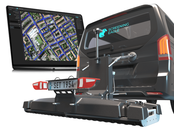
The GM8000 boasts a robust design tailored for fieldwork, equipped with interchangeable GPR arrays (GX1 and GX2) that cater to both near-surface and deep detection needs.
This flexibility ensures that users can effortlessly switch between different survey requirements with just a simple click-out and click-in mechanism.
The system's design, including a rear hitch towing system compatible with a standard vehicle, and its shock absorption feature, underscores its readiness for challenging environments.
Performance and Specifications
With radar technologies spanning 500 – 3000 MHz for the GX1 array and 30-750 MHz for the GX2 array, the GM8000 covers a broad frequency range, ensuring high-resolution data capture.
The system supports a high scan rate, up to 27,500 scans per second for GX1 and 22,000 scans per second for GX2, enabling fast data acquisition without compromising on detail.
Its acquisition speed, up to 80 km/h for GX1 and up to 180 km/h for GX2, is impressive, facilitating extensive area coverage in minimal time.
The GM8000's specifications reveal a thoughtful design: from its power supply options (Power-over-Ethernet or External 12V) to its robust connectivity features (including USB-C, Ethernet, and GNSS satellites support).
The integration of sensor fusion technology, combining GNSS, IMU, camera imaging, and wheel speed, enhances the accuracy and reliability of data capture, providing users with a comprehensive understanding of subsurface structures.
Applications and Versatility
This system is not just about power and performance; it's the breadth of its applications that truly impresses. Whether it's for utility mapping, road and bridge inspections, archaeological surveys, or precision agriculture, the GM8000 demonstrates exceptional versatility.
Its ability to deliver high-density, accurately mapped 3D data makes it invaluable for subsurface utility engineering (SUE), structural investigations, and even forensics and unexploded ordinance (UXO) detection.
Final Thoughts
The GM8000 Mobile Mapping System represents a significant leap forward in subsurface mapping technology.
Its modular design, combined with high-speed data acquisition capabilities and a wide range of applications, makes it a powerful tool for professionals across various industries.
The system's ease of use, coupled with its durability and precision, ensures that it can meet the demands of rigorous fieldwork while providing data of unparalleled quality.
For those looking to elevate their subsurface mapping capabilities, the GM8000 is undoubtedly a top-tier choice.
